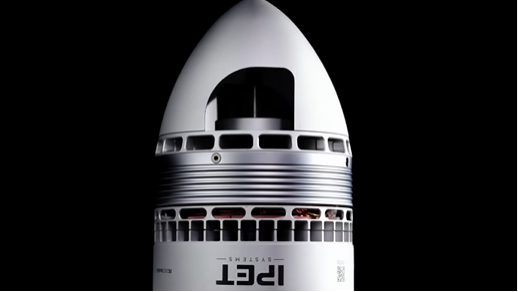
MicaSense RedEdge-P Triple on Conference for Hyperspectral Imaging in Industry in Austria

In the race to digitize agriculture, resolution is power.
At #CHII2026, the EagleNXT team isn’t just showcasing another drone sensor. They’re making a bold statement about where precision agriculture—and environmental intelligence—is heading. With the RedEdge-P Triple multispectral camera, the message is clear: satellites are no longer the gold standard.
Drones are.
On paper, the numbers alone are disruptive. While traditional satellite imagery operates at around 10 meters per pixel, the RedEdge-P Triple delivers detail down to just 2 centimeters per pixel when flown at altitude. That’s not an incremental improvement—it’s a complete shift in how the physical world can be analyzed, understood, and managed.
Fields stop being fields. They become data grids.
Each plant, each stress signal, each subtle variation in growth can now be detected, measured, and acted on—almost in real time.
But resolution is only part of the story. What makes this system fundamentally different is its vision. Not metaphorically—literally.
The RedEdge-P Triple captures 15 distinct spectral bands simultaneously, spanning visible light, red-edge and near-infrared regions. This “superspectral” capability allows operators to go far beyond simple imaging. It enables deep plant analytics: photosynthetic activity, water stress, nutrient deficiencies, disease onset—even biochemical indicators such as carotene and anthocyanin levels.
In practical terms, this means farmers are no longer reacting to visible damage. They are intervening before problems become visible at all.
Agriculture shifts from reactive to predictive.
That transformation carries major implications—not only for crop yields, but for resource efficiency. Fertilizer application can be targeted. Irrigation can be optimized. Crop diseases can be isolated before spreading across entire fields.
The economics are compelling. But the strategic dimension is even more interesting.
Because systems like this don’t just collect data—they standardize it.
With built-in radiometric calibration tools, including reflectance panels and real-time light sensing, the platform ensures that data remains consistent across flights and changing weather conditions. That enables longitudinal analysis: comparing crops not just in one moment, but across seasons, years, even climates.
In other words, this is not just observation. It’s infrastructure for decision-making.
And it’s designed for scale.
Unlike traditional imaging workflows that require lengthy post-processing, the RedEdge-P Triple integrates high-speed storage, synchronized capture, and geotagging to streamline the entire pipeline—from flight to insight. Data becomes operational—not archival.
For industries like agronomy, forestry, conservation and environmental monitoring, this shift is profound. Measuring biodiversity, tracking ecological changes, or managing large-scale agricultural operations no longer depends on coarse, delayed data. It becomes precise, immediate, and actionable.
But there is another subtle signal embedded in this launch—one that goes beyond technical specs.
The system is NDAA compliant and designed, manufactured, and engineered in the United States. In a market increasingly shaped by geopolitical tensions and supply chain scrutiny, that matters.
Drone payloads—especially sensors that generate sensitive environmental or agricultural data—are becoming strategic assets. Where they are built, how they are secured, and who controls the data pipeline is no longer a secondary consideration.
It’s part of the value proposition.
The RedEdge-P Triple reflects that shift. It is not just competing on performance—it is competing on trust.
And that may ultimately be its most powerful differentiator.
As agriculture becomes more data-driven, the tools that define that data will shape the industry itself. The ability to see earlier, react faster, and optimize continuously will separate high-performing operations from the rest.
In that future, resolution is no longer just a technical feature.
It’s a competitive edge.
And with sensors like this entering the market, the ground truth is becoming clearer than ever—down to the centimeter.
.png)