RedEdge in the Ice - How EagleNXT Drone Technology Is Mapping Life in Antarctica

Antarctica is one of the harshest environments on Earth. Temperatures plunge far below freezing, winds can exceed hurricane force, and even basic navigation tools behave unpredictably. Yet in this remote and unforgiving landscape, a small piece of technology is quietly transforming environmental science.
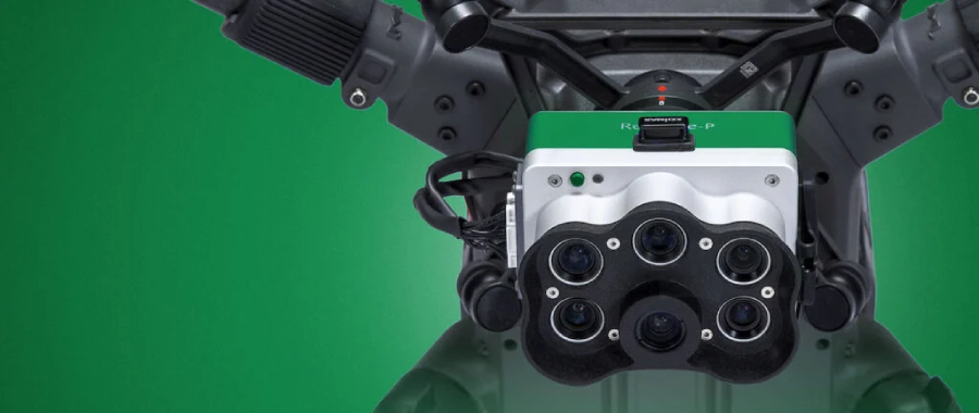
At the center of this effort is the RedEdge multispectral sensor, developed by MicaSense, now part of EagleNXT. Mounted on custom-built conservation drones, the sensor is helping researchers map fragile ecosystems that would otherwise remain invisible to the human eye.
This is not just a technological achievement — it is a new frontier in conservation science.
The work is led by Associate Professor Barbara Bollard and the DroneLab team at Auckland University of Technology (AUT). Bollard’s research spans more than two decades in geospatial science, ecosystem management, and environmental monitoring across Australia and New Zealand. Her work focuses on understanding landscapes at scale and using advanced data to guide conservation decisions.
But Antarctica posed a new kind of challenge.
The AUT DroneLab team began their Antarctic research mission in 2014 with a deceptively simple question: could drones be used to map vegetation in Antarctic Specially Protected Areas (ASPA)?
The answer turned out to be far from simple.
Traditional drones rely heavily on magnetic compasses for navigation. At high latitudes, however, magnetic interference becomes severe, making compass readings unreliable. Combine this with temperatures reaching –20°C, strong winds, and remote field conditions, and most commercial drone systems simply fail.
Faced with these limitations, the DroneLab team took an unconventional approach.
Instead of searching for a ready-made solution, UAS Engineer Ashray Doshi designed and built a custom drone platform capable of operating in extreme polar conditions. The aircraft was engineered to navigate without relying on traditional compass systems while maintaining stable flight in cold and turbulent air.
Yet even the most robust drone platform is only as valuable as the data it collects.
To map vegetation across Antarctic landscapes, the team required sensors capable of detecting subtle biological signals invisible to standard cameras. Over the years, they tested numerous RGB and multispectral imaging systems, many of which struggled to function reliably in freezing conditions.
Eventually, the team found a solution that consistently delivered results: the RedEdge multispectral sensor.
Since adopting the RedEdge platform in 2017, the DroneLab team has relied on it for mapping missions across Antarctic protected areas. Unlike conventional cameras, multispectral sensors capture light across several specific wavelengths, enabling scientists to detect plant health, vegetation density, and ecosystem changes that cannot be observed visually.
In Antarctica, this capability is invaluable.
Despite its reputation as a frozen desert, Antarctica hosts unique micro-ecosystems composed primarily of mosses and cyanobacteria. These organisms form the foundation of fragile biological communities that can be easily damaged by human activity or climate change.
Before drone mapping, much of the available vegetation data came from manual field surveys — slow, labor-intensive work that could cover only small areas at a time.
Now, drones equipped with RedEdge sensors can rapidly generate high-resolution vegetation maps, revealing exactly where moss and microbial life exist and how dense those ecosystems are.
The results have dramatically improved conservation planning.
Detailed spatial maps allow researchers to track environmental changes over time, identifying areas where vegetation is expanding, declining, or experiencing stress. Just as importantly, the data helps scientists design walking paths for researchers that minimize disturbance to sensitive habitats.
In other words, drones are not only observing Antarctica — they are helping protect it.
The Antarctic DroneLab project demonstrates the growing role of remote sensing and UAV technology in environmental science. What began as an experimental research project has evolved into a powerful tool for ecosystem monitoring in one of the planet’s most extreme environments.
As drone technology continues to advance, these tools will likely become essential for studying remote ecosystems worldwide — from polar ice fields to tropical rainforests.
In the frozen silence of Antarctica, a quiet revolution in conservation is taking flight.
And sometimes, protecting the most fragile environments begins with seeing them clearly for the first time.
.png)