How EagleNXT’s RedEdge-P Triple Seeing What Satellites Miss
.png)
For years, satellite imagery has shaped how we observe crops, forests, coastlines, and ecosystems. But satellites come with fundamental limits: coarse resolution, infrequent revisits, cloud interference, and little flexibility.
Drone-based sensing promised to close that gap. Yet most aerial sensors still operate within a narrow multispectral window - useful, but often insufficient for advanced plant physiology, early stress detection, and fine-scale ecological research.
EagleNXT’s RedEdge-P Triple camera marks a decisive shift.
Not as an incremental upgrade.
Not as a marginal improvement.
But as a move toward true superspectral imaging at drone altitude.
From Multispectral to Superspectral
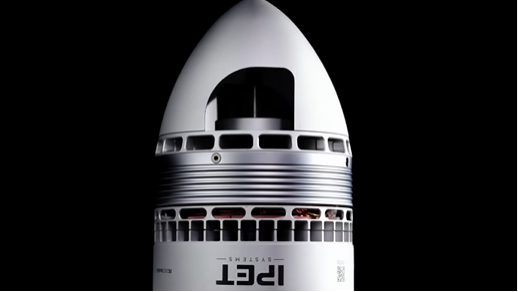
Traditional multispectral cameras typically capture five bands. The RedEdge-P Triple delivers 15 superspectral bands by combining RedEdge-P Red, RedEdge-P Blue, and RedEdge-P Green modules into a single synchronized system.
Why does this matter?
Because vegetation health is not a single metric.
Chlorophyll, carotenoids, anthocyanins, flavonoids, water content, and cellular structure all reflect light differently. Capturing more narrow, precisely positioned bands - especially in the red-edge region - allows analysts to distinguish subtle biochemical changes that five-band systems simply blur together.
The RedEdge-P Triple includes four separate red-edge bands, enabling advanced stress analysis and improved biophysical parameter extraction.
This moves drone sensing from “general vegetation health” toward something closer to plant diagnostics.
Satellite-Like Spectral Depth, Drone-Level Detail
EagleNXT positions the RedEdge-P Triple as delivering imagery comparable to Landsat and Sentinel satellite data, but at dramatically higher spatial resolution.
Using pan-sharpening technology, the system achieves 2 cm (0.8 in) per pixel resolution at 120 meters altitude.
For comparison, typical satellite products operate around 10 meters per pixel.
That difference is transformative.
At 2 cm resolution, individual leaves, rows, early-stage seedlings, and weed clusters become separable. Crop counting in early growth stages becomes feasible, especially when combined with machine learning and AI workflows.
This is no longer remote sensing at field scale.
It is remote sensing at plant scale.
Designed for Repeatability, Not Just Resolution
High resolution alone is meaningless without consistency.
Lighting conditions change constantly in real operations - clouds, sun angle, haze, and time of day all distort reflectance values. The RedEdge-P Triple addresses this with double radiometric calibration, using both an onboard light sensor and a calibration reflectance panel to maintain reliable measurements in varying illumination.
This matters for time-series analysis.
If a grower wants to compare plant stress week-to-week, or a conservation team wants to track ecosystem changes across seasons, data must be comparable - not merely visually similar.
The system is designed to support reliable time-series analysis even in changing light.
That is a quiet but critical capability.
Built for Operational Speed
Data quality collapses if capture is slow or unsynchronized.
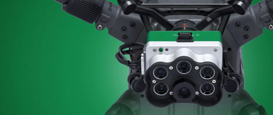
RedEdge-P Triple captures up to three raw DNG images per second, with synchronized capture of all 15 bands, automatic triggering, and geotagging.
This means:
- Faster coverage per flight
- Fewer motion artifacts
- Cleaner alignment across bands
- Simpler downstream processing
The system uses high-speed onboard storage and supports multiple interfaces including Ethernet, serial, and USB, making it adaptable across professional workflows.
It is also RTK-enabled for high positional accuracy and NDAA compliant, which matters for government and institutional users.
Beyond Agriculture
While agronomy is an obvious use case, the RedEdge-P Triple is clearly aimed at broader environmental intelligence.
Use cases include:
- Species identification and invasive detection
- Ecosystem resource surveillance
- Soil and water availability monitoring
- Coastal habitat mapping, including algae blooms and aquatic vegetation
These are complex, multi-variable problems.
They require more than NDVI.
They require spectral nuance.
The Bigger Shift
What EagleNXT is signaling with RedEdge-P Triple is a philosophical change.
Drone sensors are no longer “small satellites.”
They are becoming mobile scientific instruments.
Platforms that once offered “good enough” imagery are evolving into tools capable of biochemical insight, early warning detection, and quantitative plant physiology.
As climate pressure increases, input costs rise, and ecosystems face accelerating stress, decision-makers will demand data that explains why something is changing - not just that it is changing.
Superspectral imaging is one path toward that understanding.
RedEdge-P Triple makes it practical.
Not in orbit.
But a few hundred feet above the ground.
.png)