AgEagle and Ascent AeroSystems Launch Integrated RedEdge-P Multispectral Drone Solution for Agriculture and Research
.png)
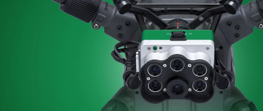
AgEagle Aerial Systems Inc. has announced the commercial availability of its MicaSense RedEdge-P multispectral camera integrated with Ascent AeroSystems’ SPIRIT™ and SPARTAN™ UAV platforms. The partnership delivers a rugged, NDAA-compliant solution designed to advance agricultural intelligence, environmental monitoring, and research applications.
A Collaboration for Smarter Aerial Insights
The RedEdge-P is one of the most advanced multispectral and panchromatic cameras on the market. Featuring five narrow multispectral bands plus a high-resolution panchromatic imager, it provides researchers and growers with sharper vegetation data and faster image processing capabilities.
Paired with Ascent’s cylindrical coaxial UAVs, the system delivers seamless integration in a quick-connect package that operators can deploy in virtually any condition. Both SPIRIT and SPARTAN are IP56-rated for all-weather use, feature modular designs, and are built for endurance.
Bill Irby, CEO of AgEagle, said the collaboration underscores a commitment to providing practical tools with direct impact:
“The integration of the RedEdge-P with Ascent’s SPIRIT and SPARTAN platforms represents a significant advancement in sensors for precision agriculture and environmental monitoring. This robust, reliable system empowers operators to streamline workflows and drive impactful results.”
Rugged Hardware Meets Cutting-Edge Sensing
Ascent’s SPIRIT and SPARTAN platforms were designed for demanding missions where reliability and portability are paramount. Their coaxial cylindrical architecture makes them more durable and more portable than conventional multirotors, while their modular payload system supports a range of sensor packages.
By embedding AgEagle’s RedEdge-P, the platforms now bring best-in-class imaging to industries where consistency and precision are critical. From crop stress analysis to forestry management and environmental surveying, the system reduces manual workloads and increases actionable intelligence.
Peter Fuchs, President of Ascent AeroSystems, noted the importance of this integration in an expanding market:
“The agricultural drone market is experiencing tremendous, rapid growth, and customers need reliable, high-performance, dependable platforms. With this integration, we are showing what is possible for future growth within the sector.”
The Role of Multispectral Imaging
Multispectral imaging has become a cornerstone in modern agriculture and environmental science. By capturing specific wavelengths of light, sensors like the RedEdge-P help detect subtle changes in plant health that are invisible to the human eye. These insights allow farmers to optimize fertilizer use, monitor irrigation, and detect early signs of disease.
For researchers, the data supports long-term monitoring of ecosystems, climate change impacts, and land-use planning. By combining sensor innovation with rugged UAV design, AgEagle and Ascent aim to make these capabilities more accessible and reliable for professionals worldwide.
NDAA Compliance and Market Positioning
In addition to performance, the integrated system is NDAA compliant, addressing growing concerns over supply chain security and data integrity. This makes the package especially attractive for government agencies, research institutions, and enterprises that prioritize U.S. and allied sourcing.
The collaboration also highlights the evolving drone ecosystem, where companies are increasingly joining forces to create turnkey solutions instead of standalone products. By pairing hardware and sensor expertise, AgEagle and Ascent are positioning themselves as leaders in agricultural and environmental UAS solutions.
Industry Growth and Outlook
The global agricultural drone market is projected to grow significantly in the next five years, driven by rising food demand, sustainability initiatives, and the need for efficient land management. Integrated solutions like the RedEdge-P on SPIRIT and SPARTAN platforms are expected to accelerate adoption by reducing technical complexity for end users.
Both companies see this as a foundation for future collaboration. With Ascent’s rugged UAV platforms already deployed in defense, public safety, and industrial markets, and AgEagle’s sensor portfolio expanding, the integration could pave the way for broader multi-sector applications.
Conclusion
Concrete runways and fields may differ in environment, but they share the same demand: reliable data, delivered quickly. By pairing AgEagle’s RedEdge-P multispectral sensor with Ascent’s SPIRIT and SPARTAN UAVs, professionals in agriculture and research now have access to sharper imagery, faster workflows, and more confident decision-making.
As agriculture faces the dual challenges of feeding a growing population and adapting to climate change, technologies like this integrated system will play a vital role in helping operators act with speed, precision, and insight.
.png)