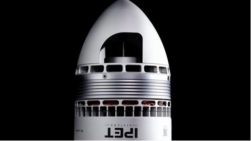
RIEGL VUX‑100 - Unmatched Clarity in Drone-Based LiDAR Mapping

High-resolution aerial mapping has taken a decisive leapforward with the introduction of RIEGL’s VUX‑100‑25 UAV LiDAR system.Engineered for unmatched precision, this lightweight yet powerful scannerbrings a 160° field of view and a pulse repetition rate of up to 1.5 MHz—transformationalspecs that promise denser, more complete datasets across diverse surveyenvironments.
The VUX‑100‑25 balances performance, weight, andflexibility. Weighing just 2.3 kgand capable of operating at altitudes up to 360 m,it is compatible with a wide range of UAVs—frommultirotors to VTOLs—while delivering up to 1.33 MHz effective measurement ratesand capturing 200 scan lines per second (riegl.co.uk). It is thiscombination of power and portability that makes the VUX‑100‑25 a go-to sensorfor high-density corridor mapping: whether over powerlines, railways, roads, orbuilt infrastructure.
The broader VUX series is renowned for pulse rates up to 2 MHz and broad compatibilityacross platforms , but the VUX‑100‑25 stands out with its tailored focus onmaximized field of view and pulse efficiency at nadir. Unlike its NFB(nadir-forward-backward) capable siblings, it optimizes for a single 160° scanning plane. This singular advantage allows operators tosweep expansive areas efficiently while maintaining high-resolution pointdensity—ideal for wide-area coverage and rapid datacapture (geoweeknews.com).
Operational efficiency is further supported by RIEGL’s RiLOC‑Fintegrated IMU/GNSS module. This compact subsystem attaches directly to theLiDAR head, bringing high-precision georeferencing without cumbersomethird-party integrations (geoweeknews.com).With native support for multiple satellite constellations and seamless tie-into RIEGL’s RiACQUIRE and RiPROCESS suites, data capture and processing areharmonized for turnkey results.
In field applications, the VUX‑100‑25 excels ininfrastructure inspection and environmental monitoring. Linear assets likeelectrical transmission lines or railway corridors benefit from the large fieldof view and rapid scan speeds, which capture fine structural detail and reduceshadowing—boosting survey completeness and minimizing costly repeat flights. Incomplex urban environments, its pulse density reveals finer features offaçades, utility poles, and urban furniture, supporting BIM and “digital twin”initiatives.
Forestry, environmental, and topographic mapping also standto gain. The VUX‑100‑25’s high pulse rate penetrates moderate canopies,delivering accurate ground models and vegetation profiles essential for carbonestimation, biomass assessment, and ecological planning. Its flight-altitudeflexibility—up to 360 m AGL—expands operational envelopes while ensuring regulatorycompliance.
RIEGL’s VUX‑100‑25 carries forward the company’s traditionof waveform-recording laser systems. Multi-echo capability and online waveformprocessing enhance accuracy and enable refined classification—from groundsurface to understory layers (riegl.co.uk). Engineers andsurveyors also benefit from the system’s mechanical stability and thermalresilience—a product of RIEGL’s aerospace-grade engineering ethos and qualityassurance.
The VUX‑100‑25’s advantages are not merely technical; theyare practical. The sensor’s lightweight cabin, minimal power requirements, andsimple mounting framework reduce UAV drag and power draw—translating to longerflight times or larger mapping areas. With a max scan altitude of 360 m and scan rates up to 200 linesper second, survey missions can cover ground quickly while maintainingsub-decimeter accuracy.
RIEGL supports hardware with a complete software ecosystem.RiACQUIRE streamlines flight mission setup, system configuration, and real-timedata monitoring. RiPROCESS transforms raw point clouds into accurate geospatialdatasets through advanced algorithms, waveform analysis, and coordinatetransformations. Additional plugins like RiHYDRO offer hydrographic processingfor coastal and inland water projects. This integration delivers provenworkflows from mission design to data delivery.
Importantly, RIEGL emphasizes customer support and systemscalability. Operators can adapt the VUX‑100‑25 across platforms—drones, mannedaircraft, or hybrid systems—while expanding payloads or upgrading IMU/GNSSkits. The company’s global service network ensures reliable operation,maintenance, and training, supporting high-stakes projects and reducing downtime.
The arrival of the VUX‑100‑25 enters a competitive landscapewhere precise, efficient, and scalable LiDAR solutions are mission-critical. Asindustries deploy drones for everything from autonomous corridor inspections tourban planning and environmental monitoring, RIEGL’s new offering raises thebar. It embodies a refined balance of pulse density, field of view, andgeospatial accuracy—backed by coherent software and field-tested reliability.
In conclusion, RIEGL’s VUX‑100‑25 UAV LiDAR scannerrepresents a significant advancement in drone-based mapping. By delivering awide 160° scan, high pulse repetition rates, and streamlined georeferencingwithin a compact, user-friendly package, it equips professionals across sectorswith powerful tools for capturing high-resolution spatial data. Asorganizations embrace UAV LiDAR for infrastructure, environment, and beyond,the VUX‑100‑25 stands out as an efficient, versatile, and high-performancesolution.