Easy Mapper Drone from Argosdyne Over the City? Europe Is Finally Learning How to Say Yes
“A drone system that can operate over populated areas?”
In Europe, that question is usually followed by hesitation, disclaimers, and eventually delay. Urban airspace has long been treated as a no‑fly zone for professional drone operations — not because the technology cannot cope, but because regulation, liability concerns, and safety assumptions were never designed for scalable use in cities.
The result is a quiet bottleneck. Urban surveying and inspection projects become slower, more expensive, or simply infeasible. Infrastructure assessments are postponed. Planning cycles stretch. Data becomes outdated before it is even collected.
This is not a technology gap. It is a regulatory and operational one.
Modern cities create some of the hardest conditions for classical surveying: dense construction, limited ground access, private property, visual obstructions from vegetation or parked vehicles. Terrestrial methods struggle. Manned aviation is inefficient. And many existing drone systems were never designed to operate lawfully and safely above people.
That is where a new category of drone systems is beginning to matter — not experimental platforms, but certified, deployable tools built specifically for urban reality.
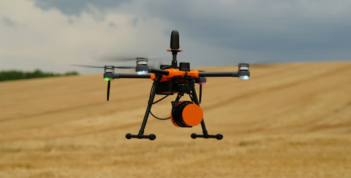
The Easy Mapper from Argosdyne represents this shift. It combines a compact drone platform with integrated LiDAR, designed from the outset for operation in populated environments under Europe’s regulatory framework. Most notably, it is certified under the EU’s C2 class — a detail that changes everything.
C2 certification allows drone operations in inhabited areas and at reduced distances from uninvolved persons, without requiring exceptional permits from aviation authorities. In practical terms, this collapses weeks or months of bureaucratic uncertainty into deployable operational planning. For urban projects, speed is often the deciding factor between execution and abandonment.
Regulation still matters. Property owners must consent to overflights, and national rules apply. But several regions, such as Germany’s Lower Saxony, already provide blanket geozone exemptions for commercial operators under defined conditions. These frameworks do not eliminate control — they modernize it.
Technology alone, however, does not close the loop.
The Easy Mapper integrates LiDAR in a true plug‑and‑play architecture, removing one of the biggest hidden costs of drone surveying: setup and calibration time. Traditional LiDAR deployments often require specialist workflows, recalibration, and prolonged pre‑flight preparation. In contrast, this system is operational within minutes.
That speed matters when operating in live urban environments.
Despite narrow streets, inner courtyards, dense vegetation, and limited take‑off zones, the system produces dense, complete point clouds with flight times of up to forty‑five minutes per section. Precision consistently reaches below 2.5 cm — and under optimal conditions, near 1 cm at lower altitudes.
Data integrity is only useful if it moves downstream. Compatibility with standard CAD and BIM environments ensures that survey data does not stall at the processing stage, a common failure point in digital infrastructure projects.
One aspect deserves particular attention in today’s political climate: origin.
For many operators working with sensitive data or critical infrastructure, “not made in China” is no longer a preference — it is a requirement. Supply‑chain trust, cybersecurity, and regulatory alignment increasingly shape procurement decisions. European‑built, regulation‑aligned systems now carry strategic weight beyond technical performance.
The broader implication is clear. Urban drone operations no longer fail because cities are too complex. They fail where institutions assume they are.
As certification, system integration, and operational maturity converge, the old assumption — that drones and cities do not mix — is collapsing. What replaces it is not disruption, but normalization.
Urban airspace is becoming usable. Carefully. Legally. Productively.
And for an industry long trapped between technical capability and regulatory hesitation, that may be the most important shift of all.

.jpg)