DJI Zenmuse L3 - Redefining Precision LiDAR Mapping with Extended Range and Real-Time Reconstruction
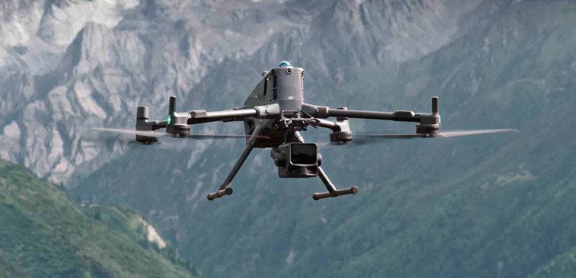
DJI has once again raised the bar in aerial mapping with the launch of the Zenmuse L3, its most advanced LiDAR payload to date. Designed as the successor to the widely adopted Zenmuse L2, the L3 brings dramatic performance upgrades that redefine what’s possible in professional surveying, forestry, construction, and infrastructure inspection.
With its extended detection range, dual 100 MP cameras, and real-time fusion reconstruction, the Zenmuse L3 sets a new benchmark for accuracy, efficiency, and workflow integration in the geospatial industry.
Extended Range and Higher Accuracy
At the heart of the Zenmuse L3 lies a next-generation laser sensor that pushes LiDAR detection to an impressive 950 meters at 10% reflectivity — more than double the reach of the L2. This leap allows operators to fly higher, survey larger areas per mission, and maintain safer altitudes over uneven or hazardous terrain.
Accuracy has also been refined to ±3–5 cm horizontally and ±2–4 cm vertically, ensuring that even long-range scans deliver crisp, reliable data. Combined with DJI’s enhanced IMU (Inertial Measurement Unit) — now 2.5× more accurate and featuring automatic calibration — the L3 guarantees high-precision mapping right from takeoff, with no time lost on warm-up routines.
Denser Point Clouds and Deeper Penetration
One of the most striking upgrades is the increase from 5 to 16 returns per pulse, giving the L3 exceptional canopy penetration. This means surveyors can now see through dense vegetation and capture detailed ground profiles beneath tree cover — a crucial advantage for forestry, archaeology, and environmental applications.
The laser spot size has also been reduced by 80%, from approximately 205 mm to just 41 mm at 120 m, producing denser point clouds and revealing finer details in structures and terrain. Together, these improvements make the L3 a tool not only for mapping the surface but for truly understanding the landscape in 3D.
Dual 100 MP Cameras for Superior Imaging
DJI pairs its advanced LiDAR module with dual 100-megapixel RGB cameras capable of 1-second capture intervals and mechanical shutters rated for 500,000 cycles. The adjustable resolution (25–100 MP) allows operators to balance image quality and data size according to mission requirements.
This dual-camera setup enhances colourised point clouds, photogrammetry, and visible-light reconstruction, meaning surveyors can now capture LiDAR and high-resolution RGB imagery simultaneously — cutting mission time and improving data alignment.
New Scanning Modes and Adaptive Intelligence
In addition to the traditional linear scanning mode, the Zenmuse L3 introduces “Star Show” and non-repetitive scanning patterns that improve accuracy and reduce blind spots, particularly under vegetation or in complex terrain.
Meanwhile, the adaptive point cloud rate dynamically adjusts laser energy based on environmental conditions, ensuring optimal performance whether flying over bright sand, dark asphalt, or forest canopies.
Real-Time Reconstruction and Smarter Workflows
Hardware alone doesn’t tell the full story — DJI’s power lies in its seamless integration of hardware and software. The L3 works hand-in-hand with upgraded versions of DJI Terra and DJI Modify, enabling real-time Gaussian splatting and fusion reconstruction.
This allows users to generate DSM/DEM models, 2D orthomosaics, and 3D digital twins directly from flight data, drastically reducing post-processing time. Large-scale projects benefit from multi-computer cluster processing, while the new cross-section tools, denoising, smoothing, and automatic classification features enhance the quality of the final datasets.
Moreover, visible-light reconstruction — using RGB imagery from the L3 — is included free for the first year, allowing operators to produce photorealistic models with minimal manual input.
Built for the Field
The Zenmuse L3 maintains an IP54 protection rating and operates in temperatures from –25°C to 55°C, ensuring reliable performance in challenging conditions. It is optimised for the M400 RTK platform, featuring single-port installation and anti-drop rails for quick, secure mounting. Although heavier than its predecessor (1.6 kg vs. 905 g), its robust design reflects the power packed within.
A Leap Forward in Aerial Mapping
The Zenmuse L3 truly embodies DJI’s promise to help professionals “see through far and true.” With double the range, triple the returns, and revolutionary software integration, it transforms how surveyors, engineers, and inspectors capture and process geospatial data.
By merging cutting-edge LiDAR performance with smart, automated workflows, DJI has delivered a payload that not only enhances data quality but accelerates the path from capture to actionable insight. For industries that rely on precision and efficiency, the Zenmuse L3 isn’t just an upgrade — it’s a game-changer.
.jpg)
%20(1).jpg)
.jpg)